Volcanoes in Iceland
Iceland is an island created by volcanoes. Here, the earth has not solidified into its final form: it slowly spreads apart, cracks and grows again. The North American and Eurasian plates are moving beneath our feet, and magma is constantly rising from the depths. This is how this island came into being: layer by layer, from lava that rose to the surface, composed of lava layers, ash and solidified rock.
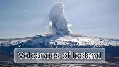
Therefore, every Icelandic volcano is not an isolated object on the map, but part of a single global process. Because of this, a volcanic eruption in Iceland is not perceived as a rare event; it continues the process of creating the island. New lava fields, cracks, even a new volcano are a logical continuation of what Iceland itself began with.
The question ‘Where is the volcano erupting?’ sounds different in Iceland than anywhere else. This relatively small island is home to over a hundred volcanic systems. About forty of them are considered active — capable of erupting (from a geological point of view) at almost any moment. When news of an active volcano in Iceland or reports of an eruption here appear, it is not just about safety. It is about an island that is once again changing its contours.
The most famous volcanoes and volcanic systems in Iceland
Name of the volcano | Height | The last eruption | Location |
|---|---|---|---|
Eyjafjallajökull | ~1,651 m | 2010 | Southern Iceland, beneath the glacier of the same name |
Grimsvötn (Grímsvötn) | ~1,725 m (under ice) | 2011 | Under the Vatnajökull glacier |
Bardarbunga (Bárðarbunga) | ~2,000 m (under ice) | 2014–2015 | Under the Vatnajökull glacier, the Bardarbunga volcanic system |
Erayfayokutl (Öræfajökull) | 2,110 m This is the highest point in Iceland (Hvannadalshnjúkur peak). | 1727–1728 | Southeast Iceland, beneath the Vatnajökull glacier |
Katla | ~1,512 m | 1918 | Under the Mirdalsjökull glacier |
Hekla | ~1,491 m | 2000 | South-central Iceland |
Krafla | ~818 m | 1984 | Northern Iceland |
Laki | The highest point, Mount Laki, has an elevation of 818 metres. | 1783–1784 | South Iceland, fissure volcanic system |
Mælifell | ~764 m | late glacial period | South Iceland, Highlands, near the Mýrdalsjökull glacier |

The Birth of Iceland | How the Earth Was Made (S1) | History
History of volcanic eruptions
The history of Iceland is a history of repeated eruptions. Volcanoes here have never been a passive backdrop, because they determined where people could live, what they could grow, and how many people would survive the next winter. Some of them changed not only the island itself, but also the world beyond its borders.
Laki: 1783–1784
The eruption of the Laki volcanic system began on 8 June 1783 and lasted until February 1784. The earth opened up along cracks more than 25 kilometres long, from which lava flowed for months. But the main threat was not the streams of molten rock, but the gases — sulphur compounds and fluorine-containing emissions.
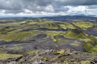
The Laki Fissure eruption, 1783-1784
In Iceland, this phenomenon was called Móðuharðindin — ‘misty poverty’. The air became unbreathable, and the water, grass and soil were poisoned. Most of the livestock died. According to various estimates, up to 20–25% of the island's population died over the following years. It was not a momentary disaster, but a slow extinction that lasted for months and whose consequences stretched over decades.
In Iceland's cultural memory, the Laki eruption is engraved as an event that called into question the very possibility of life on the island. In church texts of the time, the eruption was interpreted as a divine test or punishment. At the same time, it was during this period that the Icelanders developed their characteristic restraint in relation to the elements: not panic, but acceptance of the inevitable.
The consequences of Laki extended far beyond Iceland. In the summer of 1783, a ‘dry fog’ was recorded over Europe. France, Germany and Britain experienced abnormal weather conditions, crop failures and health problems among the population. Contemporary accounts speak of a dim sun, stifling heat and increased mortality in cities.
The winter of 1783–1784 in Europe was one of the harshest in the 18th century. Late spring and poor harvests led to food shortages and rising bread prices. In France, which was already in a state of deep socio-economic crisis, these climatic disruptions exacerbated tensions between the authorities and the population. In this context, the Laki eruption is often cited as one of the causes of the French Revolution, although the direct cause-and-effect relationship remains a subject of debate.
Eyjafjallajökull: 2010
In April 2010, the Eyjafjallajökull volcano erupted. Compared to historical catastrophes, it was a relatively minor eruption, but its cultural impact was no less significant. Magma interacting with ice formed fine ash that rose into the upper layers of the atmosphere.
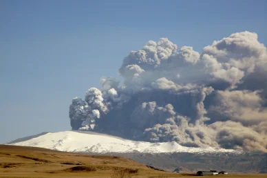
In April 2010 a series of volcanic events at Eyjafjallajökull in Iceland caused enormous disruption to air travel across Western Europe
European airspace came to a near standstill. Thousands of flights were cancelled, and people were stranded at airports. The world, accustomed to constant movement, suddenly stopped because of one Icelandic volcano.
In Iceland itself, this eruption was not perceived as an apocalypse: there was no panic, no mass casualties. For local residents, it was just another episode of coexisting with a land that lives by its own rules, but for the rest of the world, Eyjafjallajökull became a reminder of the limitations of technology and civilisation's dependence on natural processes. In cultural discourse, this eruption is often referred to as a symbol of the fragility of the global order.
Iceland's landscape was not formed once and for all; it is layered. Lava flows covered old surfaces, creating plateaus, black rocky deserts and basalt fields. Where in other countries the relief has changed over millennia of erosion, here the decisive factor was volcanic eruptions, which changed the appearance of entire regions in a matter of days.
Most of Iceland's plains are former lava fields. Over time, volcanic ash enriched the soil with minerals. Slowly, sometimes over centuries, the rock became covered with moss, lichens and grasses. This is how Iceland's characteristic vegetation was formed — low, hardy, adapted to poor soils and sudden changes in weather.
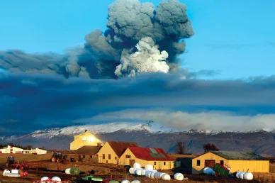
Eyjafjallajökull volcano, subglacial volcano, southern Iceland
Volcanoes also determined the island's water system. Hot springs, geothermal fields and geysers exist thanks to the heat rising from the depths. Iceland's volcanic water is rain and meltwater that passes through porous lava rocks, heats up and returns to the surface. This is how hot rivers, baths and geothermal pools came into being.
Volcanoes under glaciers play a special role. During eruptions, the heat melts the ice, forming subglacial lakes. At a certain point, the water bursts out in the form of sudden floods — jökullhlauður. They wash away everything in their path, carrying rocks, sand and ash, forming wide sandy plains in the south of the island.
Even Iceland's waterfalls are a direct result of volcanism. Rivers cross lava terraces formed by different phases of eruptions. Hard basalt layers retain their shape, while softer rocks are gradually washed away. This is how cascades and geometrically regular basalt columns appear.
Long before modern science, Icelanders were already trying to make sense of what they saw around them.
In the Elder Edda, particularly in the poem Völuspá, the description of the end of the world — Ragnarök — is filled with images that painfully resemble Icelandic reality: the sun dims, the sky blazes, and the earth sinks into the sea. These images do not seem abstract. They directly echo the real eruptions that generations of Icelanders have witnessed with their own eyes.
Here, volcanoes are neither demonised nor romanticised. They simply exist. As a force that has no intention of either saving or destroying humans. It is from this experience that the sense of monumental indifference of nature, so often noted by researchers, writers and filmmakers, grows out of Icelandic culture.
The most famous Icelandic volcanoes
There is no such thing as a ‘typical’ volcano in Iceland. Each one behaves differently, has its own history and reputation. Some are famous for a single eruption, others for their long-term and almost imperceptible activity. Together, they create a map of constant tension and change that the country has lived with for centuries.
Eyjafjallajökull — the volcano that went global
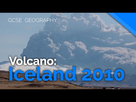
Eyjafjallajökull, Iceland 2010 (Volcano Case Study) | AQA GCSE 9-1 Geography
Until 2010, Eyjafjallajökull was known mainly to geologists and residents of southern Iceland. Its slopes are covered with ice, and the mountain itself does not look threatening. This is what makes it so significant: the danger here is not in its scale, but in the combination of fire and ice.
During the eruption, magma broke through the glacier, shattering into billions of particles of ash. This ash was so fine that it became dangerous for aviation. For Icelanders, it was just another eruption, but for the rest of the world, it was an unexpected interruption of the usual order. Eyjafjallajökull entered cultural memory as a volcano that reminded us that the global system of movement depends on very local processes.
The eruption was actively explored in documentary films, notably in Werner Herzog's 2016 film Into the Inferno. Herzog shows Iceland not as a tourist destination, but as a place where people live alongside a force that has no interest in human plans.
Grimsvötn — a constant presence beneath the ice

The Active Volcano in Iceland; Grímsvötn
Grimsvötn is Iceland's most active volcano, although most people have never seen it because it is completely hidden under the Vatnajökull glacier. Its eruptions often occur without spectacular lava columns, but with powerful consequences.
It is here that the interaction between volcanoes and ice is particularly noticeable: subglacial eruptions cause rapid melting, water accumulation and sudden floods. For Icelanders, Grimsvötn is an example of how the greatest danger is not always where it is visible. It is a volcano that is closely monitored, even when it is silent.
Bardarbunga — eruption without a summit

DJI Feats: Eruption at Bardarbunga Volcano (montage)
The 2014–2015 eruption associated with the Bardarbunga volcanic system was not accompanied by explosions from the crater. Lava flowed through cracks in the Hallihraun lava field. In terms of volume, it was one of the largest eruptions in Europe in the last two centuries.
The event showed that a volcano does not necessarily have a ‘face’. The earth can open up gradually, without dramatic explosions, but with a long-term impact on the environment. For science, it was a rare chance to observe the movement of magma over long distances beneath the surface.
Katla — a volcano of anticipation

Iceland Katla Volcano Update; [Outdated, False Positive]
Katla is one of Iceland's most talked-about volcanoes. Its last major eruption occurred in 1918, and since then it has remained active but silent. Katla is hidden beneath a thick layer of ice, which is what makes it potentially very dangerous.
In Icelandic culture, Katla often appears as ‘the one who will wake up.’ It is present in local conversations, in memories of past floods, in maps of volcanoes and risks. It is an example of a volcano that shapes not only space and landscape, but also a sense of time and expectation.
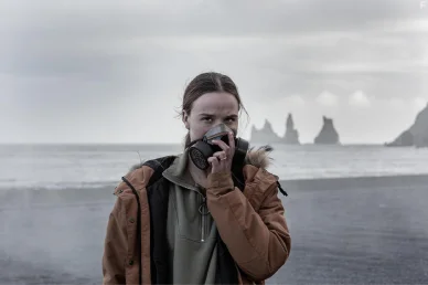
The 2021 Icelandic series Katla, filmed for Netflix
In contemporary popular culture, Katla also continues not as a spectacular explosion, but as an oppressive presence. The 2021 Icelandic series Katla, filmed for Netflix, unfolds after the volcano erupts and shows almost nothing of the disaster itself. Instead, it focuses on what remains after: the ashes, the silence, and the people trying to move on with their lives. This approach reflects the Icelandic attitude towards volcanoes: they are not dramatised, but they never disappear from view.
Gekla — ‘the gates of hell’

The history of Hekla, Iceland's most famous volcano
Hekla became perhaps the most famous Icelandic volcano in the European imagination of the Middle Ages. In the chronicles of the 12th–14th centuries, it was described as the ‘gateway to hell.’ It was believed that the souls of sinners flew over Hekla after death, and that the mountain itself was a place of punishment.
These ideas found their way into religious literature, sermons and even poetry. For Europeans who had never seen a volcano, Hekla became a symbol of uncontrolled fire and divine wrath.
For Icelanders, it was a familiar mountain, dangerous but real. Hekla was not a myth but a familiar threat. It erupted many times throughout history, and people learned to take its rhythm into account. Today, Hekla remains one of the volcanoes that can wake up almost without warning.
Krafla — a volcano as a source of knowledge

The Krafla Fires
Krafla is one of the few volcanoes in the world where geological processes could be observed almost live. A series of events known as the Krafla Fires lasted from 1975 to 1984. During this period, the Earth's crust in the region repeatedly opened up, and magma rose to a shallow depth without large-scale explosions.
It was here that it was first possible to record in detail how lithospheric plates diverge on land rather than at the bottom of the ocean. Scientists observed cycles: magma accumulation, surface deformation, and sudden stress releases. This became key material for the modern theory of rifting.
Krafla became an example of the practical use of volcanism. The Krafla geothermal power plant, launched before the end of the series of eruptions, operates nearby. At the height of volcanic activity, it was not shut down — engineers simply adapted the system to the new conditions. This decision is often cited as an example of the Icelandic approach: not to fight the elements, but to integrate into their rhythm.
Lucky — a boundary that cannot be forgotten

What happened in Iceland - The 1783 Laki volcano Eruption
Laki does not have a silhouette that can be recognised from afar. It is impossible to photograph it ‘beautifully’. It is a long line of craters and cracks scattered among lava fields. That is why the memory of Laki in Iceland is preserved not in the form of an image, but in the form of consequences.
After the eruption of 1783–1784, Icelandic society found itself on the brink of extinction. This is recorded not only in chronicles, but also in population censuses, church records, and legal documents. Some communities disappeared completely. Land that was considered suitable for living ceased to be so for decades. It was after Laki that Icelandic texts began to reflect a clear awareness that the land does not guarantee stability. This was reflected in 19th-century literature, in farmers' memoirs, and in pastoral notes. Disaster ceased to be a ‘punishment’ and became a condition of existence.
Laki also became an important reference point for science. It was his eruption that climatologists later used when they began to study the impact of volcanoes on global temperature. Data on the ‘dry fog’ of 1783 is now included in scientific models explaining the short-term global cooling at the end of the 18th century.
In modern Iceland, Laki hardly features in popular culture and is not romanticised. People go there not for the spectacle, but to understand its scale.
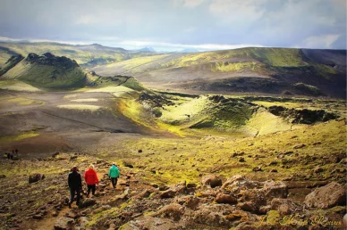
Laki it is a fissure that once opened up for tens of kilometres
Laki is not a mountain or a crater, but a fissure that once opened up for tens of kilometres. Its eruption at the end of the 18th century was a turning point for Iceland. After Laki, attitudes towards the land changed forever; it served as a reminder that life on the island is only possible if one accepts instability. It was this experience that shaped the Icelanders' reserved, attentive and almost philosophical attitude towards their volcanoes.
Mei-li-fel — the volcano from Game of Thrones
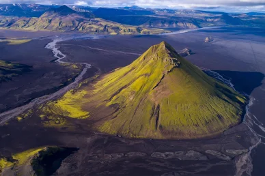
Mælifell is one of the most recognisable volcanoes in Iceland's Highlands
Mælifell is one of the most recognisable volcanoes in Iceland's Highlands. Its almost perfect cone shape stands out sharply against the black volcanic plains. In summer, the slopes are covered with bright green Thormið moss, and this contrast makes Mælifell look like a lonely green pyramid in the middle of a rocky desert.
The volcano is located in southern Iceland, near the Mýrdalsjökull glacier. The name Mælifell translates as ‘measurement hill’ — in the past, it served as a landmark in the uninhabited highlands. It is an extinct stratovolcano that formed about 10,000 years ago during the last ice age. The eruptions occurred under the ice, which determined its shape and rock composition. Today, it is not an active volcano, but rather a fixed moment in the island's geological history.
Mælifell can only be reached in summer, usually from July to October. The route follows the F210 dirt road, which requires a powerful off-road vehicle and fording glacial rivers. It is precisely the difficulty of access that has kept this landscape almost untouched for a long time.
The volcano has become recognisable even outside Iceland. Its silhouette appears in the film Noah and the TV series Game of Thrones.
In the 19th century, Iceland's volcanoes entered European popular culture through literature. The most famous example is Jules Verne's novel Journey to the Centre of the Earth. It is the Icelandic volcano Snæfellsjökull that becomes the entrance to the bowels of the planet. This is not a religious image or a chronicle of disaster, but a romantic fantasy, yet the choice of location is not accidental. For 19th-century readers, Iceland was associated with the edge of the known world, a land where nature had not yet been tamed.
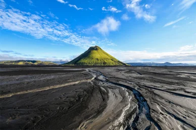
Maelifell is an epic green volcano hidden in the black Icelandic desert in the southern Highlands of Iceland
In modern Icelandic culture, volcanoes are no longer just a threat or a symbol of the end of the world. They have become part of the national identity. This is evident in literature, music and cinema. Here, the volcano is neither a hero nor an enemy. It simply exists.
Excursions to volcanoes: recommendations for tourists
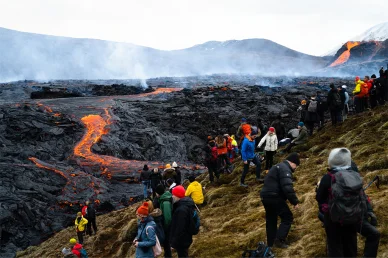
People gather at the volcanic site on the Reykjanes Peninsula following Fridays eruption in Iceland, March, 2021
- A trip to a volcano in Iceland is not an attraction in the usual sense; it is an encounter with the living earth, which does not conform to schedules and expectations. That is why the main rule here is simple: observe, do not interfere.
- When it comes to active volcanoes in Iceland, independent hiking without experience and permits is a bad idea. The safest way to see an Icelandic volcano is on an organised tour with a local guide. Guides work in conjunction with the meteorological service and rescue services and know which areas are open and which are not.
- Popular formats: hiking routes to old craters, trips to lava fields, and a helicopter tour over Iceland's volcanoes, which allows you to see the scale without risk.
- Even if a volcano appears to be ‘dormant,’ the ground nearby may be unstable. Crater rims, fissures, and lava fields often appear solid, but there may be cavities or hot spots inside. It is important to stay within the marked routes and not try to get closer ‘for the sake of a photo.’
Equipment
- waterproof clothing and wind protection are essential. The weather can change in a matter of minutes;
- sturdy footwear with good soles. Lava rock is sharp and uneven;
- water and snacks, even if the route is short;
- eye and skin protection: sun, wind and ash can all combine to cause problems.
What to do during an active eruption?
When news breaks that a volcano has erupted in Iceland, it is important to remember that:
- access to the area is almost always restricted or completely closed;
- only emergency services, scientists and organised groups are allowed to travel there;
- volcanic gases and ash can be dangerous even at a considerable distance;
- decisions to close areas are made not ‘to be on the safe side’ but for real reasons.
At times like these, it is better to observe from a distance or change your travel route. There are plenty of places in Iceland where you can see traces of past eruptions without risk.
An alternative to direct contact with the volcano
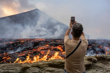
The man look at the lava flowing on Fagradalsfjall volcano in Iceland on 3 August 2022
- Old lava fields, craters, and geothermal areas are often open to visitors all year round.
- Even without an active eruption, you can tell where a volcano is erupting in Iceland by the shape of the landscape, layers of lava, and cracks in the ground.
- For many travellers, this experience is enough to feel the scale and power of the process.
- Another alternative to direct contact with a volcano is the Lava Show in Reykjavík. Here, real molten lava is demonstrated in controlled conditions, allowing you to see how magma behaves and understand the nature of eruptions without venturing into dangerous areas.
- It is also worth visiting the Volcano House in Reykjavik, a museum and educational centre that shows documentaries about real eruptions, displays lava samples and explains how volcanism works in Iceland.
- You can watch Iceland's active volcanoes in real time via 24-hour online broadcasts. The most activity is currently concentrated on the Reykjanes Peninsula, where new fissures regularly open up and lava erupts.
Here are the main resources for viewing:
- Live from Iceland — a popular website with a selection of cameras near key locations: Hagaftell, Svartsengi, Torbjörn, and others.
- YouTube channel mbl.is — the official channel of the Icelandic publication, which streams 24/7 from the sites of the latest eruptions (in particular, near the town of Grindavík).
- AfarTV (YouTube) — specialises in 4K broadcasts of volcanoes and the northern lights. Here you can often find multi-camera modes (several angles at once).
- RÚV (Icelandic National Television) — a reliable source of news and streams directly from the epicentres of activity.
- Skyline Webcams — cameras focused on the craters of Geldingadali and the surrounding area.
Tip: If you can't see anything but fog on your camera, that's normal for Icelandic weather. Try another camera or wait until dusk: that's when the lava glows most spectacularly.
Tour companies for volcanic excursions:
- Arctic Adventures — a large tour operator based in Reykjavík, offering various nature tours, including volcanic areas and geothermal zones.
- Troll.is is a local operator with a wide selection of tours in Iceland, including routes to lava fields and volcanic landforms.
- Iceland Tours is an experienced tour company offering tours of volcanic and geothermal areas, including trips from Reykjavík.
- Iceland Everywhere Tours is an operator offering personalised tours of Iceland's nature, including visits to volcanic areas.
- Iceland Go Tours is a highly rated travel agency that can also organise day trips or multi-day trips to volcanic sites.
Important: Before any trip to the volcano zone, be sure to check road conditions and safety alerts at SafeTravel.is.
A volcano is not a decoration or a show. It can be silent for decades and then change the landscape in a matter of days. Therefore, the best strategy for a tourist is to be attentive, cautious and prepared to accept that not everything will go according to plan.
In Iceland, it is not customary to ‘conquer’ nature or challenge it. Here, it is customary to live alongside it.
FAQ
❓ Is the Blue Lagoon safe during an eruption?
Generally speaking, yes, if it is officially open. The Blue Lagoon only operates when experts deem the gas levels, seismic activity and infrastructure to be safe for visitors.
❓ How many volcanoes in Iceland?
Iceland has around 130 volcanic mountains, and approximately 30 active volcanic systems across the country.
❓ How many people died during the 2010 eruption in Iceland?
There were no direct human casualties during the 2010 eruption of Eyjafjallajökull. This is often cited as an example of Iceland's effective monitoring and evacuation system.
❓ Is the Blue Lagoon in Iceland closed today?
The status of the Blue Lagoon depends on the current volcanic situation on the Reykjanes Peninsula. It may be temporarily closed or operating with restrictions, so it is worth checking the official website before travelling: https://www.bluelagoon.com/ or local service announcements.
❓ Can eruptions in Iceland create new land?
Yes. The most famous example is the island of Surtsey, which was formed by an underwater eruption in 1963. Modern fissure eruptions are also constantly increasing the area of the island with lava fields.
❓ Which volcano is currently erupting in Iceland?
As of the end of January 2026, activity is concentrated in the Sundhnúksgígar area on the Reykjanes Peninsula. Icelandic authorities warn of a high probability of new eruptions in the near future due to the prolonged accumulation of magma under the Svartsengi area.
❓ Where do volcanic eruptions occur in Iceland?
Most often, it is along rift zones where tectonic plates diverge. These are the southwest (Reykjanes), south and areas under glaciers, in particular Vatnajökull. Eruptions usually occur near the town of Grindavík and the mountain Fagradalsfjall. Although most areas around eruptions are closed to the public for safety reasons, up-to-date information on safe viewing areas or helicopter tours can be found at: https://safetravel.is/.
❓ Which volcano erupted in Iceland in 2024?
In 2024, the activity was not associated with a single classic peak, but with fissure eruptions on the Reykjanes Peninsula, in the Sundhnur system (a chain of craters) near the town of Grindavik.
❓ Where is the volcano located in Iceland?
Volcanoes are located throughout the island, but the highest concentration is along the tectonic fault that runs from the south-west to the north-east of the country.
❓ Where can you see a volcano in Iceland?
Either in nature — on lava fields, craters and volcanic systems (often with a guide) — or in a safe format, such as the Lava Show in Reykjavík, where real molten lava is demonstrated.
❓ Where is the active volcano in Iceland?
Iceland's active volcanoes do not have a single ‘permanent’ location. Most often, activity is recorded in the Reykjanes area, under the Vatnajökull glaciers and in the central part of the island. As of the end of January 2026, there are no active eruptions with lava flows. However, experts from the Icelandic Meteorological Office (IMO) warn of a high probability of a new eruption in the coming weeks due to the constant accumulation of magma under the Svartsengi area.